Pakistan’s canal irrigation gets a makeover with satellite, sensors from ADB

By MG News | January 10, 2024 at 10:55 AM GMT+05:00
January 10, 2024 (MLN): To enhance Pakistan's canal performance in support of its agriculture, the Asian Development Bank utilizes satellite imagery and soil moisture and flow sensors through the Water Financing Partnership Facility (WFPF).
This approach helps estimate variations in crop water requirements and relative water deficits across farming land that relies on the canal's extensive system, said the ADB in its latest report.
The combination of satellite-based technology and physical measurements enables the tracking of how canal water, rainfall, and groundwater are consumed through evapotranspiration, providing a comprehensive overview of water gaps.
To note, Pakistan demonstrates not only the dramatic risks to agriculture through climate-related water impacts, as witnessed during the 2022 floods and the country’s vulnerability to future shocks, but also the significant opportunities for building water resilience by piloting and modeling innovative water solutions.
WFPF investments to improve canal management in Pakistan through remote sensing-based decision support tool underline this potential.
The canal systems have been explicitly developed to supplement precipitation and distribute water as equitably as possible.
However, due to the size of the irrigation system and the scarcity of data on its precipitation and crop water needs, there is incomplete information for irrigation system managers to prepare reliable plans for volumes and timing and to quickly adapt to needs in different locations.
This results in inadequate or inequitable water distribution for farmers and end users.
The WFPF-supported approach has resulted in innovation and the novel application of high-level technology combining satellite remote sensing and mathematical modeling.
While remote sensing applications have been used elsewhere to inform farmers of irrigation requirements at the farm scale, the intervention represents the first time the technology is being used to estimate crop water deficits across a large canal command to inform the rotation of distributaries
Satellite-based irrigation performance monitoring at the head, middle, and tail sections of the canal will allow near real-time control to change water rotations, based on complementary information on rainfall forecasts and groundwater, to maximize the use and equity of water supplies.
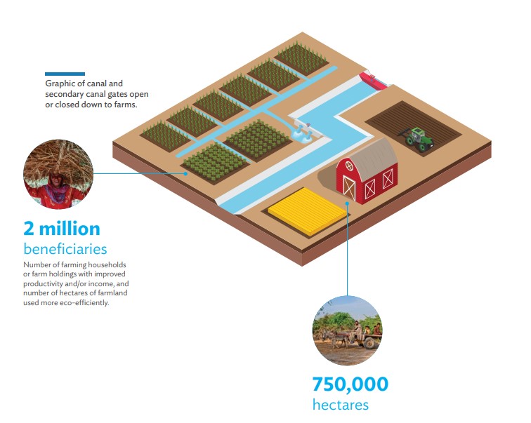
It will improve water and land management for more than 750,000 hectares of Punjab, ADB said.
The activity will benefit an estimated 2 million people, including farming households, with strengthened resilience to changing precipitation, temperature patterns, and extreme climatic events.
Rotation corrections will improve social equity, with reliable water resulting in increased food production, enhanced farm profitability, and reduced income disparity in Punjab.
Copyright Mettis Link News
Related News


| Name | Price/Vol | %Chg/NChg |
|---|---|---|
| KSE100 | 130,686.66 280.01M |
0.26% 342.63 |
| ALLSHR | 81,305.25 897.01M |
0.35% 281.26 |
| KSE30 | 39,945.45 114.02M |
0.09% 37.19 |
| KMI30 | 190,698.05 148.61M |
0.61% 1163.05 |
| KMIALLSHR | 55,074.15 495.43M |
0.53% 290.50 |
| BKTi | 34,568.40 28.73M |
-1.07% -372.33 |
| OGTi | 28,739.35 22.59M |
1.57% 443.29 |
| Symbol | Bid/Ask | High/Low |
|---|
| Name | Last | High/Low | Chg/%Chg |
|---|---|---|---|
| BITCOIN FUTURES | 110,240.00 | 110,525.00 110,155.00 |
-175.00 -0.16% |
| BRENT CRUDE | 68.85 | 69.14 68.32 |
-0.26 -0.38% |
| RICHARDS BAY COAL MONTHLY | 97.50 | 0.00 0.00 |
-0.75 -0.76% |
| ROTTERDAM COAL MONTHLY | 108.45 | 109.80 108.45 |
-0.55 -0.50% |
| USD RBD PALM OLEIN | 998.50 | 998.50 998.50 |
0.00 0.00% |
| CRUDE OIL - WTI | 67.14 | 67.18 67.00 |
0.14 0.21% |
| SUGAR #11 WORLD | 16.37 | 16.40 15.44 |
0.79 5.07% |
Chart of the Day
Latest News
Top 5 things to watch in this week
Pakistan Stock Movers
| Name | Last | Chg/%Chg |
|---|
| Name | Last | Chg/%Chg |
|---|